

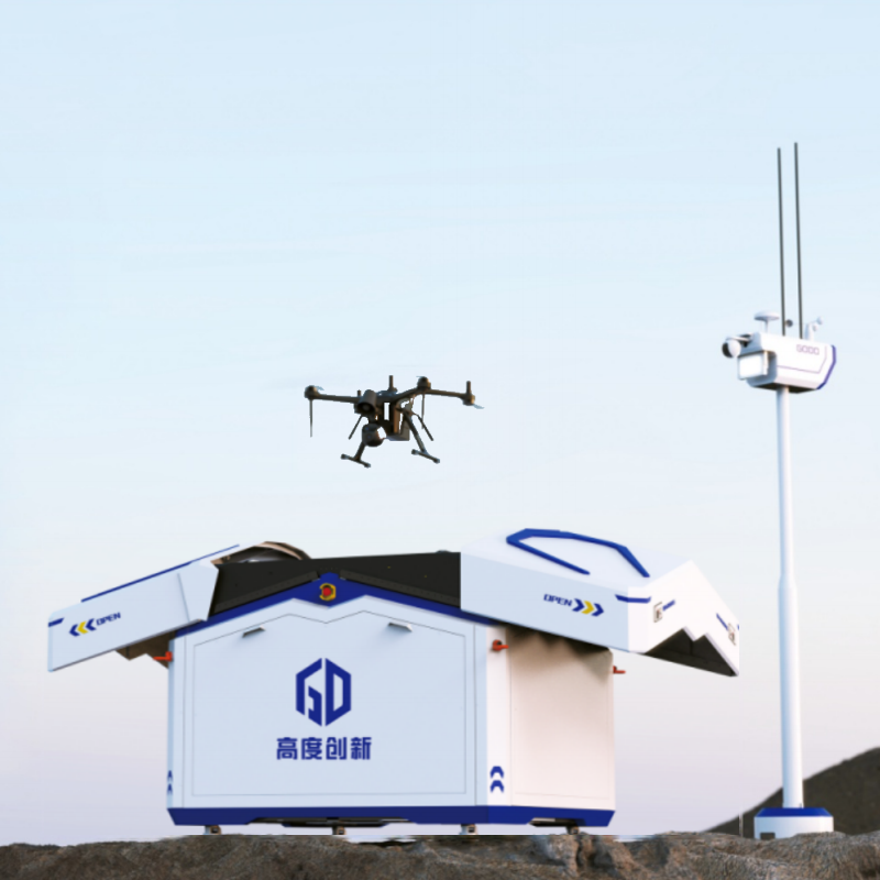
The AI Drone Intelligent Patrol System is a next-generation integrated UAV solution that combines air–ground coordination, autonomous flight control, and cloud-based mission management. It is designed for large-scale digital governance and industrial inspection scenarios, providing real-time aerial data acquisition and intelligent decision support.
The system consists of:
- Intelligent UAV airports (automated charging & deployment stations)
- Multi-type industrial drones (inspection, mapping, monitoring)
- Cloud-based remote command & control platform
- AI analytics and real-time monitoring system
Key Features
1. Fully Autonomous Drone Operations
- Automated takeoff, landing, and mission execution
- No manual piloting required
- Continuous 24/7 operation capability
- Smart battery swapping / fast charging stations
2. Smart UAV Airport System
- Automated docking and charging
- Fault self-check and maintenance alerts
- Environmental sensing (weather & air conditions)
- Supports multi-drone scheduling and fleet management
3. AI-Powered Remote Command Platform
- Real-time mission planning and dispatch
- Route planning and dynamic optimization
- Multi-drone coordination system
- Digital twin + 3D GIS visualization
- One-map integrated monitoring dashboard
4. Advanced UAV Performance
Depending on configuration (PRO / MINI / A-series):
- Flight time: up to 50–70 minutes
- Max speed: up to 23 m/s
- Max transmission distance: up to 15 km
- Wind resistance: up to level 7
- Protection rating: IP54–IP55
- RTK + AI visual positioning for precise landing
- Multi-redundancy flight safety system
5. Multi-Payload Capability
Supports modular payloads for different missions:
- HD optical cameras (inspection & surveillance)
- Thermal imaging systems
- Multispectral sensors
- Gas detection modules
- Loudspeaker & warning systems
- Searchlight / beacon systems
6. AI Intelligent Recognition
- Fire & smoke detection
- Human detection & tracking
- Vehicle identification
- Anomaly detection & alerts
- Real-time target tracking
7. Multi-Industry Application Support
The system is widely used in:
- Emergency response & disaster rescue
- Water conservancy and hydrology inspection
- Environmental monitoring & pollution control
- Public security & border patrol
- Forest fire prevention
- Urban management & smart city governance
- Transportation infrastructure inspection
System Architecture
Platform Layer
- UAV fleet management
- Flight route planning
- Task scheduling system
- Airspace & no-fly zone management
- Data storage & analytics center
- API integration with third-party systems
Hardware Layer
- Smart UAV airports (A-series / MINI / PRO stations)
- Industrial drones (multi-model compatibility)
- Sensor payload systems
Application Layer
- Emergency response
- Environmental protection
- Water resource management
- Public security
- Forestry & park management
System Advantages
- Fully autonomous aerial inspection system
- Reduces manpower and operational costs significantly
- Enables rapid emergency response (5-minute coverage circle in key regions)
- Massive data acquisition capability (millions of flight records)
- Scalable deployment across cities and regions
- Supports cross-departmental integration and digital governance
Technical Highlights
- Multi-redundant flight control system
- AI-assisted navigation and obstacle avoidance
- High-precision RTK positioning
- Cloud-based fleet orchestration
- Automated charging & maintenance system
- Secure encrypted data transmission
Deployment Results (Reference Cases)
- Large-scale deployment across multiple provinces and cities
- Over 400,000+ flight missions completed
- 3,200,000+ km total flight distance
- 270,000+ flight hours accumulated
- Applied in emergency management, environmental protection, and public safety systems
Value to Customers
This system transforms traditional manual inspection into a fully automated aerial intelligence network, enabling real-time monitoring, faster decision-making, and significantly improved operational efficiency.
It is a core infrastructure solution for smart cities and digital governance, providing a scalable “air + ground + cloud” integrated management capability.